SEAS AND OCEANS INTO THE GLOBALIZATION
Seas and oceans provide many resources. They are also essential supports of globalized exchanges: it is the maritimization of the world economy. Globalization is therefore based on seas and oceans.
How are maritime areas essential, as a medium for globalized trade?
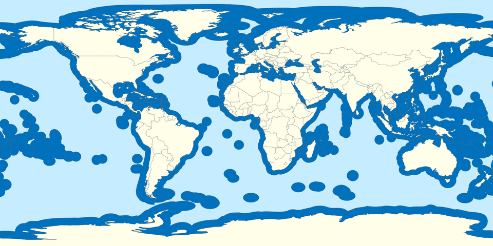
Area of the World Ocean 361.9 million square kilometers (139.7 million square miles), which covers about 70.9% of Earth’s surface, Volume 1.335 billion cubic kilometers (320.3 million cubic miles)
https://en.wikipedia.org › wiki › Ocean
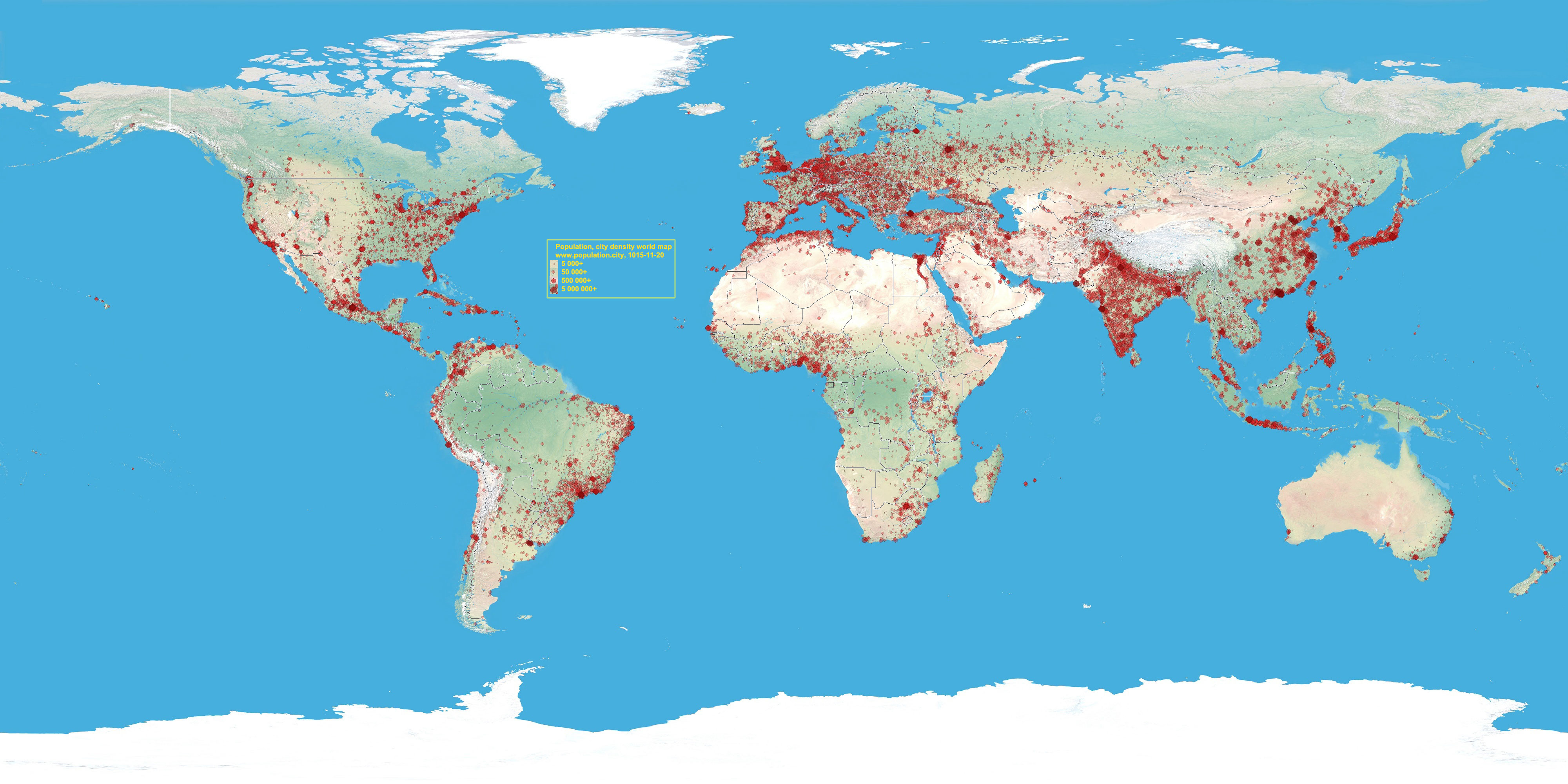
WORLD POPULATION http://population.city/images/worldpopulation.jpg

Questions
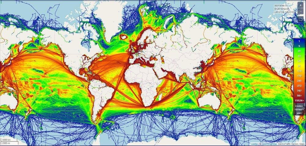
Could you make a relation between the location of the population the shipping traffic density ?
Could you identify the main roads of traffic ? for which destinations? How do you explain this fact?
PART I : The resources
What are the multiple maritime resources exploited by companies?
a) Fisheries and aquaculture: essential resources for worldwide food.
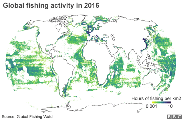
Fishery resources are the oldest exploited in the seas and oceans. About 80 million tonnes of fish are caught at sea each year. China is the main producer and exporter of fishery products, far ahead of Indonesia. This massive global fishery raises fears of resource depletion. In addition, the effects of climate change, which causes certain species to migrate to colder areas, modify the locations of fishing grounds. The share of aquaculture in animal and plant (algae) production of marine species continues to grow : it produces more than 28 million tons per year.
Document I
QUESTIONS :
Where do you locate the main zones of fishing activity?
What is the two main problem of this activity?
Use the terms sustainability EEZ and conflict

b) Energy, sand, minerals and seawater: strategic maritime resources
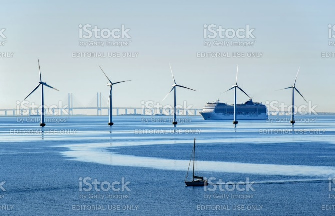
Hydrocarbons represent the largest share of marine energy resources. The offshore. Today constitutes 30% of world oil production and 27% of gas. However, these resources are unevenly distributed, which generates trade on a global scale. The seas and oceans present other energy resources that one calls Marine energy : renewable marine energies. Wind farms at sea have multiplied, especially in Europe. The force of the tide, swell or ocean currents can also be exploit to generate electricity. Finally, seawater can be desalinated. This solution is being considered by a few countries experiencing water scarcity, such as the Middle East. Sand is a strategic resource, necessary for all constructions (roads, buildings). It is the subject of intensive exploitation, especially in Sierra Leone and Indonesia where 25 islands have already disappeared.
The seas and oceans are teeming with biochemical resources and rare minerals with polymetallic nodules present in the seabed. However, these are not yet exploited for cost reasons.
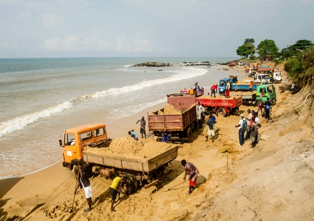
a) describe these two images.
b) how these two images show the development but also the degradation of coastal and aquatic environments.
In February 1968, Le Monde diplomatique headlined “the riches of the 21st century are to be taken from the bottom of the sea” and was interested in mining at sea. Fifty years later, it is clear that the newspaper has undoubtedly seen fair: the twenty-first century is on the way to see the concretization of « underwater mines ». Depletion of terrestrial deposits, increased demand for metals … The findings of the 1960s are still relevant today. And with the scarcity of resources, tensions relating to their supply appear. So, manufacturers and states are looking towards areas still virgin mining: the seabed. Metallic deposits are found in all oceans, at depths ranging from a few hundred to several thousand meters. Deep mineralizations, such as polymetallic nodules, […] contain metals sought after on the surface: cobalt, iron, manganese, platinum, nickel, gold, silver, copper, rare earths … Their concentrations are often there. higher than in terrestrial deposits. And the areas that could be exploited under the oceans are more extensive. 1.5 million km2 of the seabed of the Pacific Ocean is currently under exploration license. The resources are immense. […] This makes the seabed a new area to be exploited.
Hélène Ferrarini Reporterre 2018
Why the extraction of polymetallic nodules is so strategic?
Which countries are on the top in this process?
Which companies companies take part to these activities (how, investments)
| ADVANTAGES | DRAWBACKS |
Make a mental map to sum up this first part.
PART II : Maritime areas for, support for globalized trade.
How did the seas and oceans become the vectors of the majority of material and immaterial flows?
a) Most of the goods and information exchanged around the world transit through the sea
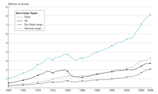
The vast majority – about 90% – of what we consume has passed by sea. The goods transported are very varied and each product corresponds to a suitable type of ship: oil (oil), gas (gas), manufactured products (container ship), grain and minerals (bulk carrier).
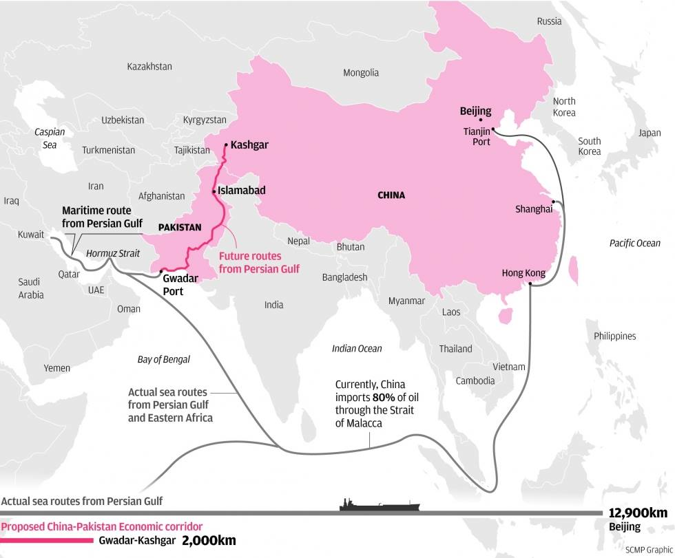
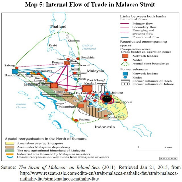
The ships follow precisely marked and supervised routes. The main flows connect the major power areas of the planet, both production and consumption areas. A few strategic passages punctuate the main roads: the Straits of Malacca, Bab-el-Mandeb, Gibraltar, Ormuz, the Suez and Panama canals and the Channel. These are choke-points.
Intangible flows are just as dependent on seas and oceans. In fact, 90% of telecommunications and the Internet pass through fiber optic cables laid at the bottom of the sea.
Maritime flows are also made up of illicit flows, such as flows linked to the drug trade, for example in the Caribbean Sea. The flows of migrants in the Mediterranean are increasing sharply and reveal the illegal migration network.
b) The maritime transport revolution
One of the major innovations in global maritime trade in the 20th century is containerization. Today, the largest container ships exceed 20,000 TEUs Twenty-foot equivalent unit (that is, more than 20,000 boxes on board) but a whole network of smaller ships provides local delivery.
The domination of maritime flows in world trade thus characterizes the maritimization of the economy. Transport costs and times have dramatically reduced thanks to various technical developments: we are talking about a revolution in maritime transport (RTM). A few large transnational firms dominate the sector, such as Maersk (Denmark) or CMA CGM (France).
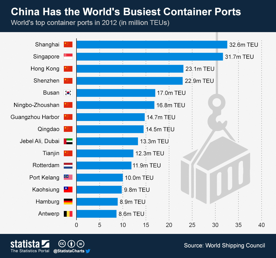
Ports around the world have adapted to the gigantism of ships and the uninterrupted growth of flows. Asian ports – and Chinese in particular – dominate today: Shanghai, Singapore, Ningbo, Shenzhen and Hong Kong.
Work by peer
Choose a subject and make a presentation about it.
conteneurization, maritimization, CMA-CGM, MAERSK, a port of you choice, the maritime silk road, Panama Canal.
Make an introduction, choose a document which symbolizes the most your subject, give the key elements about it, a conclusion.
c) New perspectives and associated risks
Maritime transport is constantly evolving, according to the economic or political situation but also according to the evolution of the environment. The Northeast Passages to northern Russia and the Northwest to Northern Canada, opened thanks to global warming and melting sea ice, are examples of this. However, the opening of these roads is still limited.
Many challenges remain to be taken up by shipping companies: dealing with regional tensions, limiting accidents (oil spills, etc.) and reducing the significant emissions of greenhouse gases from ships.


EXERCICE
SHOW IN USING THE DOCUMENTS HOW THE SEAS AND OCEANS BECOME A VECTOR OF GLOBALISATION PROCESS ?

For each document, describe it you give the accurate elements you know or you’re looking for. In last point make a link with the globalization’s process.
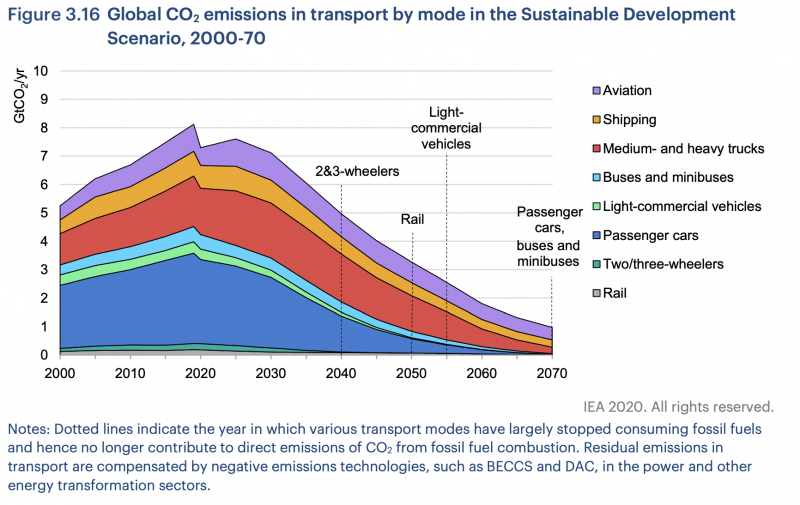
DECARBONISATION OF MARITIME TRANSPORT: RESULTS REMAIN UNSATISFACTORY
Results are rather more mixed as regards reduction of ships’ CO2 emissions. Following the strategy adopted by the IMO in April 2018, negotiations reached an impasse on adoption of short-term measures enabling stabilisation of emissions and a start to be made on their reduction. Although a number of countries expressed reservations with regard to the French proposal to regulate vessels’ speed, the subject is still very much on the agenda for future discussions. France is therefore going to continue working on the question in partnership with other States, in view of the new round of negotiations set to take place in November 2019.
France is also sorry to see creation of a permanent workgroup on CO2 postponed to the next meeting of the Committee in March 2020. This decision is stalling the momentum generated in 2018 and sends the wrong signal on international determination to make swift progress on a subject of major importance to the planet.
There has been progress in some areas, however: a method for assessing the impact of future measures on the most vulnerable States was adopted, and more ambitious energy efficiency goals for certain categories of new ships are set to come into force in 2022.
Content published under Philippe‘s Government from 2017 14th May to 2020 03rd July by French government.

A stylised undersea cable map shows the approximate routes of extensive fibreoptic lines that stretch across the ocean floor
Part III :Seas and oceans, between appropriation, protection and freedom of movement
To what extent are the seas and oceans a major geostrategic issue on a planetary scale?
I) Coveted maritime spaces
To what extent does globalization make the governance of maritime areas necessary?
a) An exploitation of the seas and oceans permitted by agreements
The oceans are major geopolitical issues. The issue of access to resources, halieutic, hydrocarbons but
also minerals (polymetallic nodules), and the right to move has been particularly reinforced with globalization.
Their exploitation by nations is governed by the UNCLOS, the United Nations Convention on the Law of the Sea, adopted in 1982 in Montego Bay. It establishes a zoning system and in particular defines the Exclusive Economic Zone (EEZ), which is an essential issue since the riparian state exercises exclusive rights to exploit resources up to 200 miles from the coast. France thus has the second largest EEZ in the world (10,754,858 km2) behind the United States (12,168,352 km2), since it combines the EEZ of the metropolis and overseas territories.
Beyond, lies the high seas which represent 64% of the surface of the seas and oceans. All the States, with or without coast, can freely exercise their activities of navigation, fishing, scientific research, overflight and laying of submarine cables, and the funds are considered as part of the common heritage of the humanity.
b) A multiplication of actors on the seas and oceans
However, this zoning is not the only framework for the exploitation of the oceans. Indeed, governance at a finer scale is necessary to deal with specific issues. For example, there are regional fisheries organizations (RFOs) bringing together different nations around the same fishing region.
The governance of the oceans is therefore exercised at several scales, and mobilizes many actors. This multiplication is reinforced by the fact that certain intergovernmental bodies have competence in matters of the marine environment: regulations on fishing techniques are issued by the FAO, for example.
c) Rivalries and conflicts around the seas and oceans
Despite everything, the oceans remain a factor of tension between States, in particular through the crucial issue of the delimitation of EEZs. Indeed, some coasts are too close for each state to obtain 200 nautical miles. Sharing is therefore often the subject of tensions, such as those observed between Slovenia and Croatia in the Adriatic Sea. In addition, the Montego Bay Convention provides for the possibility of extending a country’s EEZ on the continental shelf within the limit of 350 nautical miles. These tensions sometimes lead to conflicts, for example in the China Sea.
The oceans are also the scene of conflicts. This is evidenced by the phenomenon of contemporary piracy, which affects both merchant ships and pleasure craft. Thus, 2011 was a banner year for Somali piracy in the Gulf of Aden with more than 176 attacks. The Atalanta mission, implemented by the European Union, has since significantly reduced the number of incidents. In 2018 and 2019, acts of piracy increased sharply in the Gulf of Guinea, which has become the region most affected by piracy.
II) The ocean, a resource to protect
How to implement sustainable management of the world ocean?
a) A threatened environment
The ocean has become a priority area in the fight against climate change. The oceans are powerful climate regulators thanks to their capacity to absorb heat as well as CO2. A quarter of the CO2 produced by humans is absorbed each day by the oceans. Reservoir of threatened biodiversity, the ocean is subject to processes such as warming, acidification or rising water levels which have a lasting impact on ecosystems but also on populations, since 40% of human beings currently live in less than 100 kilometers from the sea.
The ocean is particularly affected by pollution, particularly plastic waste. The immense oceanic gyre of the “7th continent”, in the Pacific Ocean, has become its symbol. In 2017, the UN launched the #Clean Oceans campaign to encourage governments to adopt policies to reduce plastics.
To this chronic pollution is added that generated by accidents: shipwrecks as in Mauritia, but also industrial accidents, such as the explosion of the Deepwater Horizon offshore platform in 2010 in the Gulf of Mexico; or nuclear accidents, such as that at the Japanese power plant in Fukushima in 2011, during which 80% of radioactive discharges were propagated at sea.
b) Fishing, between overexploitation and sustainability
Fishing is currently a sensitive international issue. Conflicts are regular around the delimitation of fishing zones, such as between Senegalese and Mauritanian waters, where tensions erupt every year between fishermen and the coast guard.
Sustainable fishing has become a tricky concern. 31% of fish stocks are overexploited today, against less than 10% in 1974. In addition, illegal fishing accounts for 15% of total production. Sustainable fisheries management is therefore necessary, as evidenced by the rise of sustainable fisheries labels (such as MSC).
The development of aquaculture appears to be a solution to preserve marine species. However, this highly industrialized sector relies heavily on antibiotics and disinfectants and has repercussions on the environment. In addition, these farms use fish meal which causes even more overfishing.
c) Complex protection policies
► Maritime areas are today perceived as fragile resources. The need to protect the ocean is included in the 2030 Agenda adopted by the United Nations in 2015 (Sustainable Development Goal n ° 14).
► The rise of marine protected areas (MPAs) testifies to this concern. These marine environment protection areas can be fully or partially protected and their use regulated. The objectives are ecological but also tourist. Today, there are more than 11,300 MPAs, but two-thirds are only partially protected, and they currently cover only 3.7% of the world’s maritime areas.
► Finally, many NGOs, such as Greenpeace or Sea Shepherd, are actors of this governance through their work in favor of the protection of the oceans. Thus, the Greenpeace boat left in April 2019 for an exploration trip linking the North Pole to the South Pole in order to raise awareness among the general public and to act in favor of an international treaty on the creation of marine reserves .
TASK
READ THE TEXT
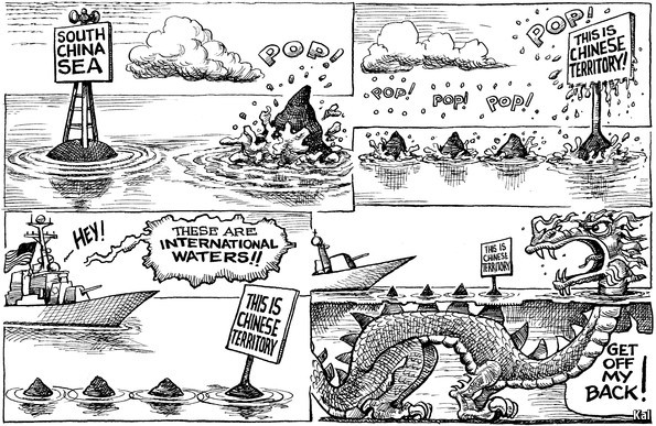
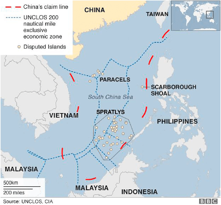
What is nine-dash line? The basis of China’s claim to sovereignty over South China Sea.
China stakes claim to 90% of the South China Sea, and this claim is based on the U-shaped nine-dash line etched on map in the 1940s by a Chinese geographer.
Southeast Asian countries like China, Vietnam, the Philippines, Brunei, Malaysia and Taiwan have disputes over the contentious South China Sea region for centuries. The two primary points of contention are the Spratly Islands and the Paracel Islands in the sea.
China’s sweeping claims of sovereignty over the sea—and the sea’s estimated 11 billion barrels of untapped oil and 190 trillion cubic feet of natural gas—have antagonized competing claimants Brunei, Indonesia, Malaysia, the Philippines, Taiwan, and Vietnam. As early as the 1970s, countries began to claim islands and various zones in the South China Sea, such as the Spratly Islands, which possess rich natural resources and fishing areas.
activities. In July 2016, the Permanent Court of Arbitration at The Hague issued its ruling on a claim brought against China by the Philippines under UNCLOS, ruling in favor of the Philippines on almost every count. While China is a signatory to the treaty, which established the tribunal, it refuses to accept the court’s authority.
In recent years, satellite imagery has shown China’s increased efforts to reclaim land in the South China Sea by physically increasing the size of islands or creating new islands altogether. In addition to piling sand onto existing reefs, China has constructed ports, military installations, and airstrips—particularly in the Paracel and Spratly Islands, where it has twenty and seven outposts, respectively. China has militarized Woody Island by deploying fighter jets, cruise missiles, and a radar system.
To protect its political, security, and economic interests in the region, the United States has challenged China’s assertive territorial claims and land reclamation efforts by conducting FONOPs and bolstering support for Southeast Asian partners. Also in response to China’s assertive presence in the disputed territory, Japan has sold military ships and equipment to the Philippines and Vietnam in order to improve their maritime security capacity and to deter Chinese aggression.
The United States, which maintains important interests in ensuring freedom of navigation and securing sea lines of communication (SLOCs), has expressed support for an agreement on a binding code of conduct and other confidence-building measures. China’s claims threaten SLOCs, which are important maritime passages that facilitate trade and the movement of naval forces.
The United States has a role in preventing military escalation resulting from the territorial dispute. Washington’s defense treaty with Manila could draw the United States into a potential China-Philippines conflict over the substantial natural gas deposits or lucrative fishing grounds in disputed territory. The failure of Chinese and Southeast Asian leaders to resolve the disputes by diplomatic means could also undermine international laws governing maritime disputes and encourage destabilizing arms buildups.
Recent Developments
Tensions between China and both the Philippines and Vietnam have recently cooled, even as China increased its military activity in the South China Sea by conducting a series of naval maneuvers and exercises in March and April 2018. Meanwhile, China continues to construct military and industrial outposts on artificial islands it has built in disputed waters.
The United States has also stepped up its military activity and naval presence in the region in recent years, including freedom of navigation operations (FONOPs) in January and March 2018. In a speech during his November 2017 visit to Southeast Asia, President Donald J. Trump emphasized the importance of such operations, and of ensuring free and open access to the South China Sea. Since May 2017, the United States has conducted six FONOPs in the region.
Questions
What is the nine dash line and the origin of the dispute ? Describe the area in quoting the countries in using the cardinal points.
What are the rules that govern this area ?
How can we describe the attitude of the Chinese authorities ? What word comes to mind ? Explain.
What does the Chinese army actually do? Why? Does it have the right?